Nang Rong Projects Data
The
largest data collection of its kind, the Nang Rong database offers
opportunities to explore critical questions about population and
environment. Longitudinal data extending 20 years from more than 50,000
individuals as well as administrative records, satellite images, and
many other sources, are linked by geographic referents and individual,
household, and community identifiers to provide a wide-ranging, flexible, and
spatially explicit database that is multi-thematic and multi-temporal.
The data are remarkable in their ability to link people, place, and
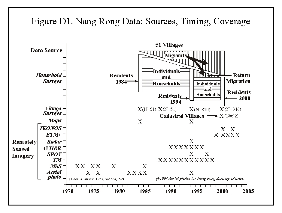
environment, and offer considerable value for research. The Nang Rong database figure
summarizes the central elements of the data.
Distinctive features of the Nang Rong data are:
- 20 years of longitudinal data on individuals
- thorough follow-up of migrants and migration processes
- documentation of complete social networks
- extensive household characteristics and village features
- incorporation into a Geographic Information System
The Nang Rong Projects data is accessible to researchers in the form
of public-use data and restricted-use data as described below.
Public-Use Data
Most of the 1984, 1994, and 2000 household census data as well as the 1995 and 2000-01 migrant follow-up data are available here for download for public use. Researchers can also download the same public-use data at the Data Sharing for Demographic Research (DSDR) project of ICPSR at the University of Michigan.
|
Restricted-Use Data
The entire household census and migrant follow-up data from 1984, 1994-95, and 2000-01, all community-level data, and some constructed social network data are now available by contractual agreement with the Data Sharing for Demographic Research (DSDR) project of ICPSR at the University of Michigan. These data are available only to researchers with an IRB-approved plan for handling and storing sensitive data who agree to keep the data confidential.
|
Descriptions of the various parts of the Nang Rong database and documentation are accessible from the following links:
Identifiers
There are several types of identifiers used throughout the Nang Rong database. This section
contains detailed descriptions on each identifier type, in addition to some documentation
for different concepts and issues related to the identifier types.
Social Survey Data
The social surveys were the starting point for research in the Nang
Rong setting. They consist of three waves of data collection -- 1984,
1994, 2000.
Spatial Data
Incorporated into the Nang Rong Project following the 1994-5 fieldwork,
the robust Nang Rong spatial database synthesizes datasets from a host
of disparate sources. Included in this unique set is a variety of
vector and raster GIS data, remotely sensed imagery, aerial
photography, and derived spatial products.
Constructed Data
There are several data files that have been constructed from different elements in the social survey and spatial analysis data.

